
Wandrer Map Overlay
View your Wandrer map data in a variety of route planning tools, including Strava, Komoot and RideWithGPS
As of June 2026, Wandrer Map Overlay has 8,000 users and a 4.38/5 rating from 32 reviews in the Entertainment category.
Usersup 60.0 percent+60.0%
8.0K
8,000
Ratingup 0.7 percent+0.7%
4.38
32 reviews
Reviewsup 3.2 percent+3.2%
32
Version
2.0.0.17
Manifest V3
90-day change · In the last 90 days this extension gained 3.0K users, 3 version updates.
History
8 snapshotsTracking since Apr 16, 2026.
View as table
| Date | Users | Rating | Reviews | Version |
|---|---|---|---|---|
| Apr 16, 2026 | 5.0K | 4.35 | 31 | 2.0.0.14 |
| Apr 26, 2026 | 5.0K | 4.35 | 31 | 2.0.0.14 |
| May 7, 2026 | 5.0K | 4.35 | 31 | 2.0.0.14 |
| May 11, 2026 | 7.0K | 4.35 | 31 | 2.0.0.15 |
| May 23, 2026 | 9.0K | 4.35 | 31 | 2.0.0.15 |
| May 28, 2026 | 7.0K | 4.35 | 31 | 2.0.0.15 |
| Jun 2, 2026 | 5.0K | 4.35 | 31 | 2.0.0.15 |
| Jun 21, 2026 | 5.0K | 4.38 | 32 | 2.0.0.16 |
| Now | 8.0K | 4.38 | 32 | 2.0.0.17 |
Changelog
- Jun 21, 2026description
The Wandrer Map Overlay Extension lets you view your Wandrer map data in many popular route planning tools, making it easy to plan routes that take you new places.

Requires an upgraded account on Wandrer.

About Wandrer
Wandrer is the outdoor game that you win by going places you've never been before. The main rule is: you get credit for every road you travel, but only once. So if you want to progress, you have to go new places. Find out more at https://wandrer.earth/

Version History:
2.0.0.16: Restore Garmin functionality
2.0.0.15: Strava fixes
2.0.0.14: RideWithGPS fixes
2.0.0.13: Komoot and BikeRouter fixes
2.0.0.11: More RideWithGPS fixes
2.0.0.10: Restore RideWithGPS compatibility
2.0.0.9: Fix issues with Garmin, Strava, and Komoot
2.0.0.8: Fix issues with Garmin, Plotaroute and Bikerouter
2.0.0.7: Improve compatibility with Strava and RideWithGPS
2.0.0.6: Address an issue with the BRouter bookmarklet
2.0.0.5: Unique distance calculation is now done by clicking a "calculate" button, rather than after every change to the route. This lightens the load on Wandrer's servers and also makes it possible to report achievement data too (forthcoming)
2.0.0.4: Fix MapMyRide/MapMyRun compatibility
2.0.0.3: Improved stability with Komoot, Strava and Bikemap
2.0.0.2: Fix Komoot compatibility, improve behavior in long routes with Strava
2.0.0.1: Manifest V3 rewrite
1.0.0.63: Restore Strava compatibility
1.0.0.61: Fix compatibility with MapMyRide/MapMyRun
1.0.0.60: Fix Komoot compatibility
1.0.0.59: Fix Garmin compatibility
1.0.0.58: Some small Bikemap and Komoot fixes
1.0.0.57: Restore compatibility with Bikemap
1.0.0.56: Add support for Google map layers in RideWithGPS and fix a bug around display of untraveled roads.
1.0.0.55: Partial fix for RideWithGPS and the Wandrer extension. The Google maps layers are not yet functional, but all others should be.
1.0.0.54: Improve compatibility with Strava, RideWithGPS, and Garmin
1.0.0.53: Fix a bike/foot icon swap in RideWithGPS
1.0.0.52: Add support for toggling paved and unpaved road visibility
1.0.0.51: Update compatibility with RideWithGPS
1.0.0.50: Go someplace together! You can now display the Wandrer data for two additional friends directly in the extension to help you plan routes together. Also fix a RideWithGPS rendering issue.
1.0.0.48: Fix compatibility with Garmin and Komoot route planners
1.0.0.47: Bugfix with changing map type on Komoot
1.0.0.46: Bugfix with Strava data display
1.0.0.45: Bugfix with Komoot data display
1.0.0.44: Bugfix with Strava data display
1.0.0.43: Bugfix with Komoot data display
1.0.0.42: Bugfix with distance reporting in MapMyRide/MapMyRun
1.0.0.41: Bugfix with distance reporting in Strava
1.0.0.40: Bugfix with distance reporting in Komoot
1.0.0.39: Show Wandrer data in additional Veloviewer maps and display traveled + unpaved roads as dashed lines
1.0.0.38: Add support for viewing Wandrer map data in the Veloviewer explorer
1.0.0.37: Fix display with different map layers in Komoot.
1.0.0.35/36: Fix a bug in the previous version where map layers weren't showing correctly.
1.0.0.34: Set default road layer colors
1.0.0.33: Improve the color picker, allowing setting of transparency
1.0.0.32: Fix RideWithGPS styling to be more consistent with other sites and the Wandrer site.
1.0.0.31: Bugfixes with the Strava route planner.
1.0.0.30: Add support for Garmin Connect route maker and fix some bugs around displaying new length
1.0.0.29: Hopefully address a bug with the extension key not being properly saved.
1.0.0.28: Bugfixes
1.0.0.27: Add early support for activities on foot
1.0.0.25: Bug fix with the popup window size being too small in Chrome 94
1.0.0.24: Bug fix with changing map styles on Komoot
1.0.0.23: Bug fix with calculating route length on Strava
1.0.0.22: More bug fixes
1.0.0.21: Bug fixes with Strava
1.0.0.20: Bug fixes
1.0.0.19: Add support for BikeRouter
1.0.0.18: Bug fixes
1.0.0.17: Added support for dynamicWatch and improved Komoot compatibility
1.0.0.16: Updated to work with Komoot once again!
1.0.0.15: Added support for Bikemap.net
1.0.0.14: Bug fixes (better Komoot support, preserve color choices after sign-out/sign-in)
1.0.0.13: Add MapMyRide/MapMyRun and Plotaroute support
1.0.0.11: Add different styling for "unpaved" roads, displaying them as dashed lines
1.0.0.10: Fix an issue with the extension not loading on Komoot route edit pages
1.0.0.9: Fix an issue with the extension not loading on Strava route edit pages
1.0.0.8: Add support for additional Komoot websites
1.0.0.7: Add support for Komoot route planner
1.0.0.6: Fix a bug where some roads were incorrectly shown as ridden in RideWithGPS
1.0.0.5: Add missing support for Strava route edit pages
1.0.0.4: Adds support for the Strava route planning tool
1.0.0.3: Also display Wandrer map data in the RWGPS route edit view
1.0.0.2: Added a live tally of the expected new length for the route, displayed under the extension's icon
1.0.0.1: Added the ability to change the color of traveled and untraveled road layers
1.0.0.0: Initial release
The Wandrer Map Overlay Extension lets you view your Wandrer map data in many popular route planning tools, making it easy to plan routes that take you new places.

Requires an upgraded account on Wandrer.

About Wandrer
Wandrer is the outdoor game that you win by going places you've never been before. The main rule is: you get credit for every road you travel, but only once. So if you want to progress, you have to go new places. Find out more at https://wandrer.earth/

Version History:
2.0.0.17: Restore Google maps layers on RideWithGPS
2.0.0.16: Restore Garmin functionality
2.0.0.15: Strava fixes
2.0.0.14: RideWithGPS fixes
2.0.0.13: Komoot and BikeRouter fixes
2.0.0.11: More RideWithGPS fixes
2.0.0.10: Restore RideWithGPS compatibility
2.0.0.9: Fix issues with Garmin, Strava, and Komoot
2.0.0.8: Fix issues with Garmin, Plotaroute and Bikerouter
2.0.0.7: Improve compatibility with Strava and RideWithGPS
2.0.0.6: Address an issue with the BRouter bookmarklet
2.0.0.5: Unique distance calculation is now done by clicking a "calculate" button, rather than after every change to the route. This lightens the load on Wandrer's servers and also makes it possible to report achievement data too (forthcoming)
2.0.0.4: Fix MapMyRide/MapMyRun compatibility
2.0.0.3: Improved stability with Komoot, Strava and Bikemap
2.0.0.2: Fix Komoot compatibility, improve behavior in long routes with Strava
2.0.0.1: Manifest V3 rewrite
1.0.0.63: Restore Strava compatibility
1.0.0.61: Fix compatibility with MapMyRide/MapMyRun
1.0.0.60: Fix Komoot compatibility
1.0.0.59: Fix Garmin compatibility
1.0.0.58: Some small Bikemap and Komoot fixes
1.0.0.57: Restore compatibility with Bikemap
1.0.0.56: Add support for Google map layers in RideWithGPS and fix a bug around display of untraveled roads.
1.0.0.55: Partial fix for RideWithGPS and the Wandrer extension. The Google maps layers are not yet functional, but all others should be.
1.0.0.54: Improve compatibility with Strava, RideWithGPS, and Garmin
1.0.0.53: Fix a bike/foot icon swap in RideWithGPS
1.0.0.52: Add support for toggling paved and unpaved road visibility
1.0.0.51: Update compatibility with RideWithGPS
1.0.0.50: Go someplace together! You can now display the Wandrer data for two additional friends directly in the extension to help you plan routes together. Also fix a RideWithGPS rendering issue.
1.0.0.48: Fix compatibility with Garmin and Komoot route planners
1.0.0.47: Bugfix with changing map type on Komoot
1.0.0.46: Bugfix with Strava data display
1.0.0.45: Bugfix with Komoot data display
1.0.0.44: Bugfix with Strava data display
1.0.0.43: Bugfix with Komoot data display
1.0.0.42: Bugfix with distance reporting in MapMyRide/MapMyRun
1.0.0.41: Bugfix with distance reporting in Strava
1.0.0.40: Bugfix with distance reporting in Komoot
1.0.0.39: Show Wandrer data in additional Veloviewer maps and display traveled + unpaved roads as dashed lines
1.0.0.38: Add support for viewing Wandrer map data in the Veloviewer explorer
1.0.0.37: Fix display with different map layers in Komoot.
1.0.0.35/36: Fix a bug in the previous version where map layers weren't showing correctly.
1.0.0.34: Set default road layer colors
1.0.0.33: Improve the color picker, allowing setting of transparency
1.0.0.32: Fix RideWithGPS styling to be more consistent with other sites and the Wandrer site.
1.0.0.31: Bugfixes with the Strava route planner.
1.0.0.30: Add support for Garmin Connect route maker and fix some bugs around displaying new length
1.0.0.29: Hopefully address a bug with the extension key not being properly saved.
1.0.0.28: Bugfixes
1.0.0.27: Add early support for activities on foot
1.0.0.25: Bug fix with the popup window size being too small in Chrome 94
1.0.0.24: Bug fix with changing map styles on Komoot
1.0.0.23: Bug fix with calculating route length on Strava
1.0.0.22: More bug fixes
1.0.0.21: Bug fixes with Strava
1.0.0.20: Bug fixes
1.0.0.19: Add support for BikeRouter
1.0.0.18: Bug fixes
1.0.0.17: Added support for dynamicWatch and improved Komoot compatibility
1.0.0.16: Updated to work with Komoot once again!
1.0.0.15: Added support for Bikemap.net
1.0.0.14: Bug fixes (better Komoot support, preserve color choices after sign-out/sign-in)
1.0.0.13: Add MapMyRide/MapMyRun and Plotaroute support
1.0.0.11: Add different styling for "unpaved" roads, displaying them as dashed lines
1.0.0.10: Fix an issue with the extension not loading on Komoot route edit pages
1.0.0.9: Fix an issue with the extension not loading on Strava route edit pages
1.0.0.8: Add support for additional Komoot websites
1.0.0.7: Add support for Komoot route planner
1.0.0.6: Fix a bug where some roads were incorrectly shown as ridden in RideWithGPS
1.0.0.5: Add missing support for Strava route edit pages
1.0.0.4: Adds support for the Strava route planning tool
1.0.0.3: Also display Wandrer map data in the RWGPS route edit view
1.0.0.2: Added a live tally of the expected new length for the route, displayed under the extension's icon
1.0.0.1: Added the ability to change the color of traveled and untraveled road layers
1.0.0.0: Initial release
- Jun 2, 2026description
The Wandrer Map Overlay Extension lets you view your Wandrer map data in many popular route planning tools, making it easy to plan routes that take you new places.

Requires an upgraded account on Wandrer.

About Wandrer
Wandrer is the outdoor game that you win by going places you've never been before. The main rule is: you get credit for every road you travel, but only once. So if you want to progress, you have to go new places. Find out more at https://wandrer.earth/

Version History:
2.0.0.15: Strava fixes
2.0.0.14: RideWithGPS fixes
2.0.0.13: Komoot and BikeRouter fixes
2.0.0.11: More RideWithGPS fixes
2.0.0.10: Restore RideWithGPS compatibility
2.0.0.9: Fix issues with Garmin, Strava, and Komoot
2.0.0.8: Fix issues with Garmin, Plotaroute and Bikerouter
2.0.0.7: Improve compatibility with Strava and RideWithGPS
2.0.0.6: Address an issue with the BRouter bookmarklet
2.0.0.5: Unique distance calculation is now done by clicking a "calculate" button, rather than after every change to the route. This lightens the load on Wandrer's servers and also makes it possible to report achievement data too (forthcoming)
2.0.0.4: Fix MapMyRide/MapMyRun compatibility
2.0.0.3: Improved stability with Komoot, Strava and Bikemap
2.0.0.2: Fix Komoot compatibility, improve behavior in long routes with Strava
2.0.0.1: Manifest V3 rewrite
1.0.0.63: Restore Strava compatibility
1.0.0.61: Fix compatibility with MapMyRide/MapMyRun
1.0.0.60: Fix Komoot compatibility
1.0.0.59: Fix Garmin compatibility
1.0.0.58: Some small Bikemap and Komoot fixes
1.0.0.57: Restore compatibility with Bikemap
1.0.0.56: Add support for Google map layers in RideWithGPS and fix a bug around display of untraveled roads.
1.0.0.55: Partial fix for RideWithGPS and the Wandrer extension. The Google maps layers are not yet functional, but all others should be.
1.0.0.54: Improve compatibility with Strava, RideWithGPS, and Garmin
1.0.0.53: Fix a bike/foot icon swap in RideWithGPS
1.0.0.52: Add support for toggling paved and unpaved road visibility
1.0.0.51: Update compatibility with RideWithGPS
1.0.0.50: Go someplace together! You can now display the Wandrer data for two additional friends directly in the extension to help you plan routes together. Also fix a RideWithGPS rendering issue.
1.0.0.48: Fix compatibility with Garmin and Komoot route planners
1.0.0.47: Bugfix with changing map type on Komoot
1.0.0.46: Bugfix with Strava data display
1.0.0.45: Bugfix with Komoot data display
1.0.0.44: Bugfix with Strava data display
1.0.0.43: Bugfix with Komoot data display
1.0.0.42: Bugfix with distance reporting in MapMyRide/MapMyRun
1.0.0.41: Bugfix with distance reporting in Strava
1.0.0.40: Bugfix with distance reporting in Komoot
1.0.0.39: Show Wandrer data in additional Veloviewer maps and display traveled + unpaved roads as dashed lines
1.0.0.38: Add support for viewing Wandrer map data in the Veloviewer explorer
1.0.0.37: Fix display with different map layers in Komoot.
1.0.0.35/36: Fix a bug in the previous version where map layers weren't showing correctly.
1.0.0.34: Set default road layer colors
1.0.0.33: Improve the color picker, allowing setting of transparency
1.0.0.32: Fix RideWithGPS styling to be more consistent with other sites and the Wandrer site.
1.0.0.31: Bugfixes with the Strava route planner.
1.0.0.30: Add support for Garmin Connect route maker and fix some bugs around displaying new length
1.0.0.29: Hopefully address a bug with the extension key not being properly saved.
1.0.0.28: Bugfixes
1.0.0.27: Add early support for activities on foot
1.0.0.25: Bug fix with the popup window size being too small in Chrome 94
1.0.0.24: Bug fix with changing map styles on Komoot
1.0.0.23: Bug fix with calculating route length on Strava
1.0.0.22: More bug fixes
1.0.0.21: Bug fixes with Strava
1.0.0.20: Bug fixes
1.0.0.19: Add support for BikeRouter
1.0.0.18: Bug fixes
1.0.0.17: Added support for dynamicWatch and improved Komoot compatibility
1.0.0.16: Updated to work with Komoot once again!
1.0.0.15: Added support for Bikemap.net
1.0.0.14: Bug fixes (better Komoot support, preserve color choices after sign-out/sign-in)
1.0.0.13: Add MapMyRide/MapMyRun and Plotaroute support
1.0.0.11: Add different styling for "unpaved" roads, displaying them as dashed lines
1.0.0.10: Fix an issue with the extension not loading on Komoot route edit pages
1.0.0.9: Fix an issue with the extension not loading on Strava route edit pages
1.0.0.8: Add support for additional Komoot websites
1.0.0.7: Add support for Komoot route planner
1.0.0.6: Fix a bug where some roads were incorrectly shown as ridden in RideWithGPS
1.0.0.5: Add missing support for Strava route edit pages
1.0.0.4: Adds support for the Strava route planning tool
1.0.0.3: Also display Wandrer map data in the RWGPS route edit view
1.0.0.2: Added a live tally of the expected new length for the route, displayed under the extension's icon
1.0.0.1: Added the ability to change the color of traveled and untraveled road layers
1.0.0.0: Initial release
The Wandrer Map Overlay Extension lets you view your Wandrer map data in many popular route planning tools, making it easy to plan routes that take you new places.

Requires an upgraded account on Wandrer.

About Wandrer
Wandrer is the outdoor game that you win by going places you've never been before. The main rule is: you get credit for every road you travel, but only once. So if you want to progress, you have to go new places. Find out more at https://wandrer.earth/

Version History:
2.0.0.16: Restore Garmin functionality
2.0.0.15: Strava fixes
2.0.0.14: RideWithGPS fixes
2.0.0.13: Komoot and BikeRouter fixes
2.0.0.11: More RideWithGPS fixes
2.0.0.10: Restore RideWithGPS compatibility
2.0.0.9: Fix issues with Garmin, Strava, and Komoot
2.0.0.8: Fix issues with Garmin, Plotaroute and Bikerouter
2.0.0.7: Improve compatibility with Strava and RideWithGPS
2.0.0.6: Address an issue with the BRouter bookmarklet
2.0.0.5: Unique distance calculation is now done by clicking a "calculate" button, rather than after every change to the route. This lightens the load on Wandrer's servers and also makes it possible to report achievement data too (forthcoming)
2.0.0.4: Fix MapMyRide/MapMyRun compatibility
2.0.0.3: Improved stability with Komoot, Strava and Bikemap
2.0.0.2: Fix Komoot compatibility, improve behavior in long routes with Strava
2.0.0.1: Manifest V3 rewrite
1.0.0.63: Restore Strava compatibility
1.0.0.61: Fix compatibility with MapMyRide/MapMyRun
1.0.0.60: Fix Komoot compatibility
1.0.0.59: Fix Garmin compatibility
1.0.0.58: Some small Bikemap and Komoot fixes
1.0.0.57: Restore compatibility with Bikemap
1.0.0.56: Add support for Google map layers in RideWithGPS and fix a bug around display of untraveled roads.
1.0.0.55: Partial fix for RideWithGPS and the Wandrer extension. The Google maps layers are not yet functional, but all others should be.
1.0.0.54: Improve compatibility with Strava, RideWithGPS, and Garmin
1.0.0.53: Fix a bike/foot icon swap in RideWithGPS
1.0.0.52: Add support for toggling paved and unpaved road visibility
1.0.0.51: Update compatibility with RideWithGPS
1.0.0.50: Go someplace together! You can now display the Wandrer data for two additional friends directly in the extension to help you plan routes together. Also fix a RideWithGPS rendering issue.
1.0.0.48: Fix compatibility with Garmin and Komoot route planners
1.0.0.47: Bugfix with changing map type on Komoot
1.0.0.46: Bugfix with Strava data display
1.0.0.45: Bugfix with Komoot data display
1.0.0.44: Bugfix with Strava data display
1.0.0.43: Bugfix with Komoot data display
1.0.0.42: Bugfix with distance reporting in MapMyRide/MapMyRun
1.0.0.41: Bugfix with distance reporting in Strava
1.0.0.40: Bugfix with distance reporting in Komoot
1.0.0.39: Show Wandrer data in additional Veloviewer maps and display traveled + unpaved roads as dashed lines
1.0.0.38: Add support for viewing Wandrer map data in the Veloviewer explorer
1.0.0.37: Fix display with different map layers in Komoot.
1.0.0.35/36: Fix a bug in the previous version where map layers weren't showing correctly.
1.0.0.34: Set default road layer colors
1.0.0.33: Improve the color picker, allowing setting of transparency
1.0.0.32: Fix RideWithGPS styling to be more consistent with other sites and the Wandrer site.
1.0.0.31: Bugfixes with the Strava route planner.
1.0.0.30: Add support for Garmin Connect route maker and fix some bugs around displaying new length
1.0.0.29: Hopefully address a bug with the extension key not being properly saved.
1.0.0.28: Bugfixes
1.0.0.27: Add early support for activities on foot
1.0.0.25: Bug fix with the popup window size being too small in Chrome 94
1.0.0.24: Bug fix with changing map styles on Komoot
1.0.0.23: Bug fix with calculating route length on Strava
1.0.0.22: More bug fixes
1.0.0.21: Bug fixes with Strava
1.0.0.20: Bug fixes
1.0.0.19: Add support for BikeRouter
1.0.0.18: Bug fixes
1.0.0.17: Added support for dynamicWatch and improved Komoot compatibility
1.0.0.16: Updated to work with Komoot once again!
1.0.0.15: Added support for Bikemap.net
1.0.0.14: Bug fixes (better Komoot support, preserve color choices after sign-out/sign-in)
1.0.0.13: Add MapMyRide/MapMyRun and Plotaroute support
1.0.0.11: Add different styling for "unpaved" roads, displaying them as dashed lines
1.0.0.10: Fix an issue with the extension not loading on Komoot route edit pages
1.0.0.9: Fix an issue with the extension not loading on Strava route edit pages
1.0.0.8: Add support for additional Komoot websites
1.0.0.7: Add support for Komoot route planner
1.0.0.6: Fix a bug where some roads were incorrectly shown as ridden in RideWithGPS
1.0.0.5: Add missing support for Strava route edit pages
1.0.0.4: Adds support for the Strava route planning tool
1.0.0.3: Also display Wandrer map data in the RWGPS route edit view
1.0.0.2: Added a live tally of the expected new length for the route, displayed under the extension's icon
1.0.0.1: Added the ability to change the color of traveled and untraveled road layers
1.0.0.0: Initial release
- May 7, 2026description
The Wandrer Map Overlay Extension lets you view your Wandrer map data in many popular route planning tools, making it easy to plan routes that take you new places.

Requires an upgraded account on Wandrer.

About Wandrer
Wandrer is the outdoor game that you win by going places you've never been before. The main rule is: you get credit for every road you travel, but only once. So if you want to progress, you have to go new places. Find out more at https://wandrer.earth/

Version History:
2.0.0.14: RideWithGPS fixes
2.0.0.13: Komoot and BikeRouter fixes
2.0.0.11: More RideWithGPS fixes
2.0.0.10: Restore RideWithGPS compatibility
2.0.0.9: Fix issues with Garmin, Strava, and Komoot
2.0.0.8: Fix issues with Garmin, Plotaroute and Bikerouter
2.0.0.7: Improve compatibility with Strava and RideWithGPS
2.0.0.6: Address an issue with the BRouter bookmarklet
2.0.0.5: Unique distance calculation is now done by clicking a "calculate" button, rather than after every change to the route. This lightens the load on Wandrer's servers and also makes it possible to report achievement data too (forthcoming)
2.0.0.4: Fix MapMyRide/MapMyRun compatibility
2.0.0.3: Improved stability with Komoot, Strava and Bikemap
2.0.0.2: Fix Komoot compatibility, improve behavior in long routes with Strava
2.0.0.1: Manifest V3 rewrite
1.0.0.63: Restore Strava compatibility
1.0.0.61: Fix compatibility with MapMyRide/MapMyRun
1.0.0.60: Fix Komoot compatibility
1.0.0.59: Fix Garmin compatibility
1.0.0.58: Some small Bikemap and Komoot fixes
1.0.0.57: Restore compatibility with Bikemap
1.0.0.56: Add support for Google map layers in RideWithGPS and fix a bug around display of untraveled roads.
1.0.0.55: Partial fix for RideWithGPS and the Wandrer extension. The Google maps layers are not yet functional, but all others should be.
1.0.0.54: Improve compatibility with Strava, RideWithGPS, and Garmin
1.0.0.53: Fix a bike/foot icon swap in RideWithGPS
1.0.0.52: Add support for toggling paved and unpaved road visibility
1.0.0.51: Update compatibility with RideWithGPS
1.0.0.50: Go someplace together! You can now display the Wandrer data for two additional friends directly in the extension to help you plan routes together. Also fix a RideWithGPS rendering issue.
1.0.0.48: Fix compatibility with Garmin and Komoot route planners
1.0.0.47: Bugfix with changing map type on Komoot
1.0.0.46: Bugfix with Strava data display
1.0.0.45: Bugfix with Komoot data display
1.0.0.44: Bugfix with Strava data display
1.0.0.43: Bugfix with Komoot data display
1.0.0.42: Bugfix with distance reporting in MapMyRide/MapMyRun
1.0.0.41: Bugfix with distance reporting in Strava
1.0.0.40: Bugfix with distance reporting in Komoot
1.0.0.39: Show Wandrer data in additional Veloviewer maps and display traveled + unpaved roads as dashed lines
1.0.0.38: Add support for viewing Wandrer map data in the Veloviewer explorer
1.0.0.37: Fix display with different map layers in Komoot.
1.0.0.35/36: Fix a bug in the previous version where map layers weren't showing correctly.
1.0.0.34: Set default road layer colors
1.0.0.33: Improve the color picker, allowing setting of transparency
1.0.0.32: Fix RideWithGPS styling to be more consistent with other sites and the Wandrer site.
1.0.0.31: Bugfixes with the Strava route planner.
1.0.0.30: Add support for Garmin Connect route maker and fix some bugs around displaying new length
1.0.0.29: Hopefully address a bug with the extension key not being properly saved.
1.0.0.28: Bugfixes
1.0.0.27: Add early support for activities on foot
1.0.0.25: Bug fix with the popup window size being too small in Chrome 94
1.0.0.24: Bug fix with changing map styles on Komoot
1.0.0.23: Bug fix with calculating route length on Strava
1.0.0.22: More bug fixes
1.0.0.21: Bug fixes with Strava
1.0.0.20: Bug fixes
1.0.0.19: Add support for BikeRouter
1.0.0.18: Bug fixes
1.0.0.17: Added support for dynamicWatch and improved Komoot compatibility
1.0.0.16: Updated to work with Komoot once again!
1.0.0.15: Added support for Bikemap.net
1.0.0.14: Bug fixes (better Komoot support, preserve color choices after sign-out/sign-in)
1.0.0.13: Add MapMyRide/MapMyRun and Plotaroute support
1.0.0.11: Add different styling for "unpaved" roads, displaying them as dashed lines
1.0.0.10: Fix an issue with the extension not loading on Komoot route edit pages
1.0.0.9: Fix an issue with the extension not loading on Strava route edit pages
1.0.0.8: Add support for additional Komoot websites
1.0.0.7: Add support for Komoot route planner
1.0.0.6: Fix a bug where some roads were incorrectly shown as ridden in RideWithGPS
1.0.0.5: Add missing support for Strava route edit pages
1.0.0.4: Adds support for the Strava route planning tool
1.0.0.3: Also display Wandrer map data in the RWGPS route edit view
1.0.0.2: Added a live tally of the expected new length for the route, displayed under the extension's icon
1.0.0.1: Added the ability to change the color of traveled and untraveled road layers
1.0.0.0: Initial release
The Wandrer Map Overlay Extension lets you view your Wandrer map data in many popular route planning tools, making it easy to plan routes that take you new places.

Requires an upgraded account on Wandrer.

About Wandrer
Wandrer is the outdoor game that you win by going places you've never been before. The main rule is: you get credit for every road you travel, but only once. So if you want to progress, you have to go new places. Find out more at https://wandrer.earth/

Version History:
2.0.0.15: Strava fixes
2.0.0.14: RideWithGPS fixes
2.0.0.13: Komoot and BikeRouter fixes
2.0.0.11: More RideWithGPS fixes
2.0.0.10: Restore RideWithGPS compatibility
2.0.0.9: Fix issues with Garmin, Strava, and Komoot
2.0.0.8: Fix issues with Garmin, Plotaroute and Bikerouter
2.0.0.7: Improve compatibility with Strava and RideWithGPS
2.0.0.6: Address an issue with the BRouter bookmarklet
2.0.0.5: Unique distance calculation is now done by clicking a "calculate" button, rather than after every change to the route. This lightens the load on Wandrer's servers and also makes it possible to report achievement data too (forthcoming)
2.0.0.4: Fix MapMyRide/MapMyRun compatibility
2.0.0.3: Improved stability with Komoot, Strava and Bikemap
2.0.0.2: Fix Komoot compatibility, improve behavior in long routes with Strava
2.0.0.1: Manifest V3 rewrite
1.0.0.63: Restore Strava compatibility
1.0.0.61: Fix compatibility with MapMyRide/MapMyRun
1.0.0.60: Fix Komoot compatibility
1.0.0.59: Fix Garmin compatibility
1.0.0.58: Some small Bikemap and Komoot fixes
1.0.0.57: Restore compatibility with Bikemap
1.0.0.56: Add support for Google map layers in RideWithGPS and fix a bug around display of untraveled roads.
1.0.0.55: Partial fix for RideWithGPS and the Wandrer extension. The Google maps layers are not yet functional, but all others should be.
1.0.0.54: Improve compatibility with Strava, RideWithGPS, and Garmin
1.0.0.53: Fix a bike/foot icon swap in RideWithGPS
1.0.0.52: Add support for toggling paved and unpaved road visibility
1.0.0.51: Update compatibility with RideWithGPS
1.0.0.50: Go someplace together! You can now display the Wandrer data for two additional friends directly in the extension to help you plan routes together. Also fix a RideWithGPS rendering issue.
1.0.0.48: Fix compatibility with Garmin and Komoot route planners
1.0.0.47: Bugfix with changing map type on Komoot
1.0.0.46: Bugfix with Strava data display
1.0.0.45: Bugfix with Komoot data display
1.0.0.44: Bugfix with Strava data display
1.0.0.43: Bugfix with Komoot data display
1.0.0.42: Bugfix with distance reporting in MapMyRide/MapMyRun
1.0.0.41: Bugfix with distance reporting in Strava
1.0.0.40: Bugfix with distance reporting in Komoot
1.0.0.39: Show Wandrer data in additional Veloviewer maps and display traveled + unpaved roads as dashed lines
1.0.0.38: Add support for viewing Wandrer map data in the Veloviewer explorer
1.0.0.37: Fix display with different map layers in Komoot.
1.0.0.35/36: Fix a bug in the previous version where map layers weren't showing correctly.
1.0.0.34: Set default road layer colors
1.0.0.33: Improve the color picker, allowing setting of transparency
1.0.0.32: Fix RideWithGPS styling to be more consistent with other sites and the Wandrer site.
1.0.0.31: Bugfixes with the Strava route planner.
1.0.0.30: Add support for Garmin Connect route maker and fix some bugs around displaying new length
1.0.0.29: Hopefully address a bug with the extension key not being properly saved.
1.0.0.28: Bugfixes
1.0.0.27: Add early support for activities on foot
1.0.0.25: Bug fix with the popup window size being too small in Chrome 94
1.0.0.24: Bug fix with changing map styles on Komoot
1.0.0.23: Bug fix with calculating route length on Strava
1.0.0.22: More bug fixes
1.0.0.21: Bug fixes with Strava
1.0.0.20: Bug fixes
1.0.0.19: Add support for BikeRouter
1.0.0.18: Bug fixes
1.0.0.17: Added support for dynamicWatch and improved Komoot compatibility
1.0.0.16: Updated to work with Komoot once again!
1.0.0.15: Added support for Bikemap.net
1.0.0.14: Bug fixes (better Komoot support, preserve color choices after sign-out/sign-in)
1.0.0.13: Add MapMyRide/MapMyRun and Plotaroute support
1.0.0.11: Add different styling for "unpaved" roads, displaying them as dashed lines
1.0.0.10: Fix an issue with the extension not loading on Komoot route edit pages
1.0.0.9: Fix an issue with the extension not loading on Strava route edit pages
1.0.0.8: Add support for additional Komoot websites
1.0.0.7: Add support for Komoot route planner
1.0.0.6: Fix a bug where some roads were incorrectly shown as ridden in RideWithGPS
1.0.0.5: Add missing support for Strava route edit pages
1.0.0.4: Adds support for the Strava route planning tool
1.0.0.3: Also display Wandrer map data in the RWGPS route edit view
1.0.0.2: Added a live tally of the expected new length for the route, displayed under the extension's icon
1.0.0.1: Added the ability to change the color of traveled and untraveled road layers
1.0.0.0: Initial release
Permissions & access
- Permissions
- activeTabstoragedeclarativeNetRequest
- Host access
- https://*.wandrer.earth/*, https://*.ridewithgps.com/*, https://*.strava.com/*, https://*.komoot.com/*, https://*.bikemap.net/*, https://*.mapmyride.com/*, https://*.plotaroute.com/*, https://*.veloviewer.com/*, https://*.connect.garmin.com/*, https://*.bikerouter.de/*
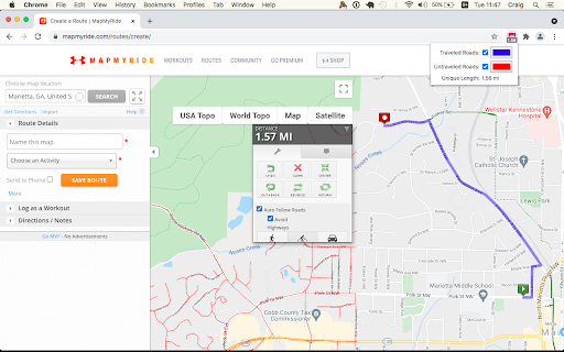
Screenshots


About
The Wandrer Map Overlay Extension lets you view your Wandrer map data in many popular route planning tools, making it easy to plan routes that take you new places.

Requires an upgraded account on Wandrer.

About Wandrer
Wandrer is the outdoor game that you win by going places you've never been before. The main rule is: you get credit for every road you travel, but only once. So if you want to progress, you have to go new places. Find out more at https://wandrer.earth/

Version History:
2.0.0.17: Restore Google maps layers on RideWithGPS
2.0.0.16: Restore Garmin functionality
2.0.0.15: Strava fixes
2.0.0.14: RideWithGPS fixes
2.0.0.13: Komoot and BikeRouter fixes
2.0.0.11: More RideWithGPS fixes
2.0.0.10: Restore RideWithGPS compatibility
2.0.0.9: Fix issues with Garmin, Strava, and Komoot
2.0.0.8: Fix issues with Garmin, Plotaroute and Bikerouter
2.0.0.7: Improve compatibility with Strava and RideWithGPS
2.0.0.6: Address an issue with the BRouter bookmarklet
2.0.0.5: Unique distance calculation is now done by clicking a "calculate" button, rather than after every change to the route. This lightens the load on Wandrer's servers and also makes it possible to report achievement data too (forthcoming)
2.0.0.4: Fix MapMyRide/MapMyRun compatibility
2.0.0.3: Improved stability with Komoot, Strava and Bikemap
2.0.0.2: Fix Komoot compatibility, improve behavior in long routes with Strava
2.0.0.1: Manifest V3 rewrite
1.0.0.63: Restore Strava compatibility
1.0.0.61: Fix compatibility with MapMyRide/MapMyRun
1.0.0.60: Fix Komoot compatibility
1.0.0.59: Fix Garmin compatibility
1.0.0.58: Some small Bikemap and Komoot fixes
1.0.0.57: Restore compatibility with Bikemap
1.0.0.56: Add support for Google map layers in RideWithGPS and fix a bug around display of untraveled roads.
1.0.0.55: Partial fix for RideWithGPS and the Wandrer extension. The Google maps layers are not yet functional, but all others should be.
1.0.0.54: Improve compatibility with Strava, RideWithGPS, and Garmin
1.0.0.53: Fix a bike/foot icon swap in RideWithGPS
1.0.0.52: Add support for toggling paved and unpaved road visibility
1.0.0.51: Update compatibility with RideWithGPS
1.0.0.50: Go someplace together! You can now display the Wandrer data for two additional friends directly in the extension to help you plan routes together. Also fix a RideWithGPS rendering issue.
1.0.0.48: Fix compatibility with Garmin and Komoot route planners
1.0.0.47: Bugfix with changing map type on Komoot
1.0.0.46: Bugfix with Strava data display
1.0.0.45: Bugfix with Komoot data display
1.0.0.44: Bugfix with Strava data display
1.0.0.43: Bugfix with Komoot data display
1.0.0.42: Bugfix with distance reporting in MapMyRide/MapMyRun
1.0.0.41: Bugfix with distance reporting in Strava
1.0.0.40: Bugfix with distance reporting in Komoot
1.0.0.39: Show Wandrer data in additional Veloviewer maps and display traveled + unpaved roads as dashed lines
1.0.0.38: Add support for viewing Wandrer map data in the Veloviewer explorer
1.0.0.37: Fix display with different map layers in Komoot.
1.0.0.35/36: Fix a bug in the previous version where map layers weren't showing correctly.
1.0.0.34: Set default road layer colors
1.0.0.33: Improve the color picker, allowing setting of transparency
1.0.0.32: Fix RideWithGPS styling to be more consistent with other sites and the Wandrer site.
1.0.0.31: Bugfixes with the Strava route planner.
1.0.0.30: Add support for Garmin Connect route maker and fix some bugs around displaying new length
1.0.0.29: Hopefully address a bug with the extension key not being properly saved.
1.0.0.28: Bugfixes
1.0.0.27: Add early support for activities on foot
1.0.0.25: Bug fix with the popup window size being too small in Chrome 94
1.0.0.24: Bug fix with changing map styles on Komoot
1.0.0.23: Bug fix with calculating route length on Strava
1.0.0.22: More bug fixes
1.0.0.21: Bug fixes with Strava
1.0.0.20: Bug fixes
1.0.0.19: Add support for BikeRouter
1.0.0.18: Bug fixes
1.0.0.17: Added support for dynamicWatch and improved Komoot compatibility
1.0.0.16: Updated to work with Komoot once again!
1.0.0.15: Added support for Bikemap.net
1.0.0.14: Bug fixes (better Komoot support, preserve color choices after sign-out/sign-in)
1.0.0.13: Add MapMyRide/MapMyRun and Plotaroute support
1.0.0.11: Add different styling for "unpaved" roads, displaying them as dashed lines
1.0.0.10: Fix an issue with the extension not loading on Komoot route edit pages
1.0.0.9: Fix an issue with the extension not loading on Strava route edit pages
1.0.0.8: Add support for additional Komoot websites
1.0.0.7: Add support for Komoot route planner
1.0.0.6: Fix a bug where some roads were incorrectly shown as ridden in RideWithGPS
1.0.0.5: Add missing support for Strava route edit pages
1.0.0.4: Adds support for the Strava route planning tool
1.0.0.3: Also display Wandrer map data in the RWGPS route edit view
1.0.0.2: Added a live tally of the expected new length for the route, displayed under the extension's icon
1.0.0.1: Added the ability to change the color of traveled and untraveled road layers
1.0.0.0: Initial release
Technical
- Version
- 2.0.0.17
- Manifest
- V3
- Size
- 792KiB
- Min Chrome
- 88
- Languages
- 1
- Featured
- No
Metadata
- ID
- nmcamjnbjejckmdbobepfjdehbfillan
- Developer ID
- uc72eb823119037a455354f607aa53edb
- Developer Email
- [email protected]
- Created
- Dec 24, 2020
- Last Updated (Store)
- Jun 12, 2026
- Last Scraped
- Jun 21, 2026
- Website
- wandrer.earth
- Support URL
- —
- Privacy Policy
- https://wandrer.earth/privacy
Similar extensions
Alternatives to Wandrer Map Overlay, ranked by description similarity.
VeloViewer Strava Plugin
Additions to Strava website to provide helpful links and features for VeloViewer.
10.0K
★ 4.8
Strava Enhanced Maps
Extension Strava qui permet d'ajouter de nouveaux fonds de carte au planificateur d'itinéraire.
2.0K
★ 4.7
Strava Extension: Street View, Maps & Advanced Analytics
Strava extension for maps, Street View, advanced analytics & workout insights.
706
★ 5.0
ZwiftMap for Strava
Replace real-world maps with Zwift maps when visiting Strava
2.0K
★ 3.9
Strava Helper
Some tweaks for Strava. Adds a "Give Kudos to All" button, removes clutter and provides UI tweaks.
1.0K
★ 3.6
Tracker Pro Mode
Switch Sailing Tracker to Pro !
79
★ 5.0
StatsHunters
Show tiles on Strava route builder
10.0K
★ 5.0
Sauce for Strava™
Additional functionality for your cycling and running analysis. This extension upgrades the Strava™ website.
50.0K
★ 4.7
Data sourced from the Chrome Web Store · last verified Jun 21, 2026.