
Geocoding API by PostGrid
Geocode, Reverse Geocode, Verify, Autocomplete and Parse Address Data Across the World (250 Countries and Territories)
As of May 2026, Geocoding API by PostGrid has 538 users in the Developer Tools category.
Usersup 7.6 percent+7.6%
538
538
Ratingno change0%
—
— reviews
Reviewsno change0%
—
Version
1.0
Manifest V3
History
3 snapshotsTracking since Apr 1, 2026.
View as table
| Date | Users | Rating | Reviews | Version |
|---|---|---|---|---|
| Apr 1, 2026 | 500 | — | — | 1.0 |
| Apr 30, 2026 | 529 | — | — | 1.0 |
| May 27, 2026 | 544 | — | — | 1.0 |
| Now | 538 | — | — | 1.0 |
Permissions & access
- Permissions
- None declared
- Host access
- None declared
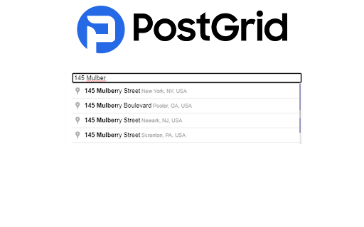
Screenshots
About
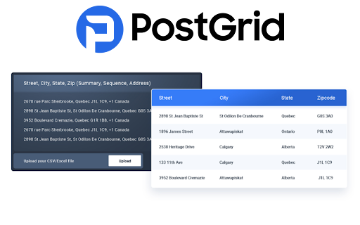
What is a Geocoding API?

A Geocoding API is a service that translates postal addresses (like "1600 Amphitheatre Parkway, Mountain View, CA") into geographic coordinates (like latitude 37.423021 and longitude -122.083739), which can be used to place markers on a map, or position the map. Conversely, reverse geocoding is the process of converting geographic coordinates (like latitude and longitude data) into a human-readable address.

Key features of a Geocoding API typically include:

- Address to Coordinates Conversion: Takes a textual address and returns its precise geographic location in terms of latitude and longitude.

- Coordinates to Address Conversion (Reverse Geocoding): Takes latitude and longitude coordinates and returns the corresponding address, which might include the street name, city, state, and country.

- Batch Geocoding: Allows multiple addresses to be submitted in one request, returning geographic coordinates for each.

- Partial Address Lookup: Offers suggestions for completing addresses as users type them, improving accuracy and user experience.

- Location Autocomplete: Provides auto-completion suggestions for addresses or places as a user types, based on previously entered data.

- Area-Based Results: Can provide information on the broader area surrounding an address, such as the district, city, or postal code area.

- Support for Various Address Formats: Accepts and processes addresses in different formats specific to various countries or regions.

Geocoding APIs are used in a wide range of applications, including mapping and navigation tools, location-based services, real estate platforms, and in any system where translating addresses to geographic coordinates or vice versa is necessary. They are fundamental in delivering personalized, location-aware digital experiences.

Enhance Your Geocoding Solutions with PostGrid's Geocoding API

Introducing PostGrid’s Geocoding API, tailored for various online platforms including E-Commerce sites, food delivery apps, and mobile applications. Leveraging certified data from authoritative sources, our API offers precise geolocation services, ensuring the accuracy of location data for addresses.

Key Features of PostGrid's Geocoding API:

For E-Commerce Platforms:
Improve user experience: Offer precise location suggestions for billing and shipping addresses, reducing user input effort.
Enhance conversions: Incorporate accurate geolocation data to streamline checkout processes.

For Food Delivery Apps:
Reliable delivery locations: Ensure precise geocoding for timely and accurate deliveries.
Build brand trust: Consistently provide accurate location data for customer addresses.

For Mobile Applications:
Ease sign-up processes: Auto-fill geolocation data for a smooth user experience.
Maintain accurate data: Keep customer location records precise and up-to-date.

For Custom Software:
Exact location capture: Integrate precise geolocation data into bespoke applications.
Data enhancement: Regularly refine and update location records using our API.

For KYC (Know Your Customer) Applications:
Authentic location sourcing: Utilize up-to-date and accurate geolocation data for customer verification.
Maintain data quality: Ensure the precision and relevance of customer location information.

Developer Insights for PostGrid’s Geocoding API:

Geolocation Accuracy: Provide location suggestions based on comprehensive and current data.

Detailed Location Data: Offer granular details like specific building numbers or apartment units.

Broad Coverage: Include comprehensive data for diverse locations, enhancing global usability.

Real-time Geocoding: Deliver instant and precise location data as soon as a user inputs an address.

Location Parsing: Decompose complex addresses into understandable components for easier processing.

Guaranteed Accuracy: Ensure the use of only verified, precise location data.

Instant Validation: Employ real-time geocoding for optimal location data accuracy.

Elevate your platform's geolocation capabilities with PostGrid's Geocoding API, ensuring a streamlined, precise, and user-friendly location input experience.
Technical
- Version
- 1.0
- Manifest
- V3
- Size
- 25.6KiB
- Min Chrome
- 88
- Languages
- 1
- Featured
- Yes
Metadata
- ID
- nlcmfkppjeehffkpipcdkblpphjdiheh
- Developer ID
- uf154c5f3470825bf8e1e8e01fd3789b0
- Developer Email
- [email protected]
- Created
- Dec 31, 2023
- Last Updated (Store)
- May 2, 2024
- Last Scraped
- May 27, 2026
- Website
- http://www.postgrid.com/
- Support URL
- https://www.postgrid.com/geocoding-api/
- Privacy Policy
- https://www.postgrid.com/legal/
Similar extensions
Alternatives to Geocoding API by PostGrid, ranked by description similarity.
ZIP Code API by PostGrid
Geocode, Reverse Geocode, Verify and Identify Zip Code of Address Data Across the World (250 Countries and Territories)
33
Address Verification API by PostGrid
Verify, Validate, Autocomplete, Standardize and Parse Address Data Across the World (250 Countries and Territories)
15
Address Autocomplete API by PostGrid™
Autocomplete, Geocode, Reverse Geocode, Verify and Validate Address Data Across the World (250 Countries and Territories)
244
Address Validation API by PostGrid
Verify, Validate, Autocomplete, Standardize and Parse Address Data Across the World
4
International Address Verification - PostGrid
Verify, Validate, Autocomplete, Standardize and Parse Address Data Across the World (250 Countries and Territories)
17
USPS Address Verification by PostGrid™
Autocomplete, Geocode, Reverse Geocode, Verify and Validate USPS Address Data & Across the World (250 Countries and Territories)
39
Bulk Address Verification by PostGrid
Verify, Validate, Autocomplete, Standardize and Parse Bulk and Batch Address Data Across the World (250 Countries and Territories)
184
★ 5.0
Lat Long to Address Bulk Converter
This tool converts latitude-longitude coordinates to physical addresses in bulk and provides the output in a downloadable CSV file.
641
★ 3.3
Data sourced from the Chrome Web Store · last verified May 27, 2026.