
Zone
Zone - Drone / UAV /Quadcopter pilot flight resources! - No Flight Zones - Flight Advisory Zones - TFRs - Show cities with laws…
As of May 2026, Zone has — users.
Usersno change0%
—
—
Ratingno change0%
—
— reviews
Reviewsno change0%
—
Version
1.0.7
Manifest V2
History
1 snapshotsTracking since May 1, 2026.
Not enough history yet for this metric — the chart fills in as we collect more snapshots.
View as table
| Date | Users | Rating | Reviews | Version |
|---|---|---|---|---|
| May 1, 2026 | — | — | — | 1.0.7 |
| Now | — | — | — | 1.0.7 |
Permissions & access
- Permissions
- unlimitedStoragenotificationsaccessibilityFeatures.readvideoCapturealarmsstorageoverrideEscFullscreenfullscreengeolocation
- Host access
- https://clients2.google.com/
Screenshots
About
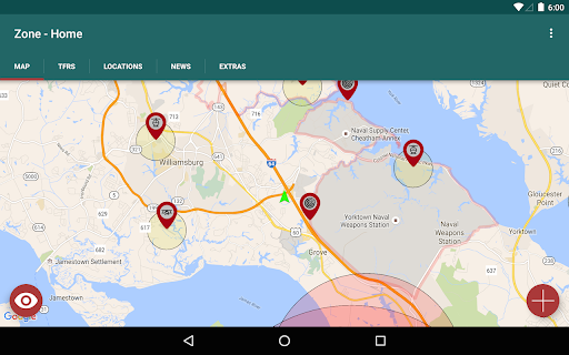
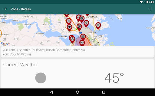
Zone - Drone / UAV /Quadcopter pilot flight resources!

- No Flight Zones
- Flight Advisory Zones
- TFRs
- Show cities with laws against flights
- Make reports to help others find/avoid flight areas
 - Good Flights (with ratings)
 - Bad Flights (with ratings)
 - Bad Neighbors
 - Hazards
 - Pictures
- Location of power plants (power sources)
- Save and View Favorite Locations
 - Includes Zone Data
 - Weather
 - Air Quality
 - K-Index
 - METARs
 - TAFs
 - Sunrise / Sunset
 - Air Quality
 - Location Geo Information
 - News

*We are constantly working on new features! If there's something you'd like to see implemented, let us know!*

*Areas represented do not always mean you cannot fly there! Keep in mind of local laws, and contact flight towers when needed*
Technical
- Version
- 1.0.7
- Manifest
- V2
- Size
- 17.24MiB
- Min Chrome
- 23
- Languages
- 39
- Featured
- No
Metadata
- ID
- gocoaohmicajbjjnekiphcfgnobjgadf
- Developer ID
- ud308a60ad4eb1b5aff680d7fbcae7b29
- Developer Email
- —
- Created
- Dec 13, 2015
- Last Updated (Store)
- Jan 29, 2016
- Last Scraped
- May 29, 2026
- Website
- —
- Support URL
- —
- Privacy Policy
- —
Similar extensions
Alternatives to Zone, ranked by description similarity.
Nearest Airports Locator
Locate Nearest Airports List on Map to determine Travel Optimal Routes and the Drone Safe Fly Zone
13
Pilot Brief ZA
SA pilots' cockpit companion — live METAR/TAF, weather links, NOTAMs, UTC clock, squawk codes and unit converter.
7
Zeen
Zeen, building road awareness together! Zeen is a fully featured, community driven mapping solution.
Features:
- Over…
—
NOTAM Spot (Beta)
BETA: Automatically detect critical risks in NOTAM, METAR, and TAF. Your essential extra layer of safety for every flight.
21
★ 5.0
Metam
Metam - For all your aviation weather needs
FAQ: http://goo.gl/VAMzij
Metam is everything you've wanted for your global aviation…
8
★ 4.0
FlightPulse - Delay Predictions
See flight delay predictions before you book. Works on Google Flights, Expedia, Kayak, Delta, United, and more.
6
★ 5.0
FlySafe - Avoid Boeing Flights
Avoid traveling on Boeing airplanes with this simple chrome extension
4
Weather: Temps + Rolling-Month Rain
High/low temps for the previous 7 days plus today, rolling month rainfall, and AM/PM condition summary.
3
Data sourced from the Chrome Web Store · last verified May 29, 2026.